How Did Satellite Company Inmarsat Track Down Flight MH370 With 19th-Century Technology?
The revelation that MH370 ended in the southern Indian Ocean is based on new analysis by UK investigators and the British satellite firm Inmarsat. Here's how they did it.
Analysis by the British satellite company Inmarsat and the UK's Air Accidents Investigation Branch was cited on Monday by PM Najib as the source of information that has narrowed the location where MH370 may have crashed into the southern Indian Ocean
While planes and ships have scoured the oceans and speculation has ebbed and flowed about the fate of Flight MH370, scientists at Inmarsat have spent the past fortnight crunching vast amounts of data to provide the first solid information relating to the fate of the Boeing 777 and the 239 people onboard. Inmarsat on Monday revealed the grim conclusion of its calculations – that the plane had plunged into the freezing waters of the Indian Ocean some 1,500 miles south-west of Australia.
Malaysian Prime Minister Najib Razak (C) delivers a statement on the missing Malaysia Airlines flight MH370 during a press conference at the Putra World Trade Center (PWTC) in Kuala Lumpur on March 24, 2014
Image via says.comOn 24 March, around 10:00 pm, PM Najib said new analysis of satellite data showed that the last known position of the Boeing 777 was over a remote area of the southern Indian Ocean, far from any possible landing sites. "It is therefore with deep sadness and regret that I must inform you that according to new data, flight MH370 ended in the southern Indian Ocean," he told reporters in a late-night news conference.
rt.comInmarsat was set up in 1979 by the International Maritime Organisation to help ships stay in touch with shore or call for emergency no matter where they were. The firm employs about 1,600 staff.
Set up 35 years ago as a not-for-profit organisation to provide communications for shipping, Inmarsat has since become one of the world’s largest satellite operators.
n addition to its own satellites, Inmarsat has a collaboration agreement with ACeS regarding handheld voice services.
Image via wikimedia.orgInmarsat's control room in London, like some of its other 60 locations worldwide, looks like a miniature version of Nasa: a huge screen displays the positions of its 11 geostationary satellites, and dozens of monitors control and correct their positions. A press on a key can cause the puff of a rocket on a communications satellite 22,236 miles away, nudging its orbit by a few inches this way or that.
More prosaically, Inmarsat's systems enable passengers to make calls from their seats and also to use Wi-Fi and connect to the internet while flying. If the plane has its own "picocell" essentially a tiny mobile phone tower set up inside the plane then that can be linked to the satellite communications system and enable passengers to use their own mobile phones to make calls, which are routed through the satellite and back to earth.
telegraph.co.ukAfter its creation, Inmarsat's maritime role rapidly expanded to providing connectivity for airlines, the media, oil and gas companies, mining and construction in remote areas, and governments. Privatised at the end of the 1990s, Inmarsat was floated on the stock market in 2004, and now focuses on providing services to four main areas: maritime, enterprise (focused on businesses including aviation), civil and military work for the US government, and civil and military work for other governments.
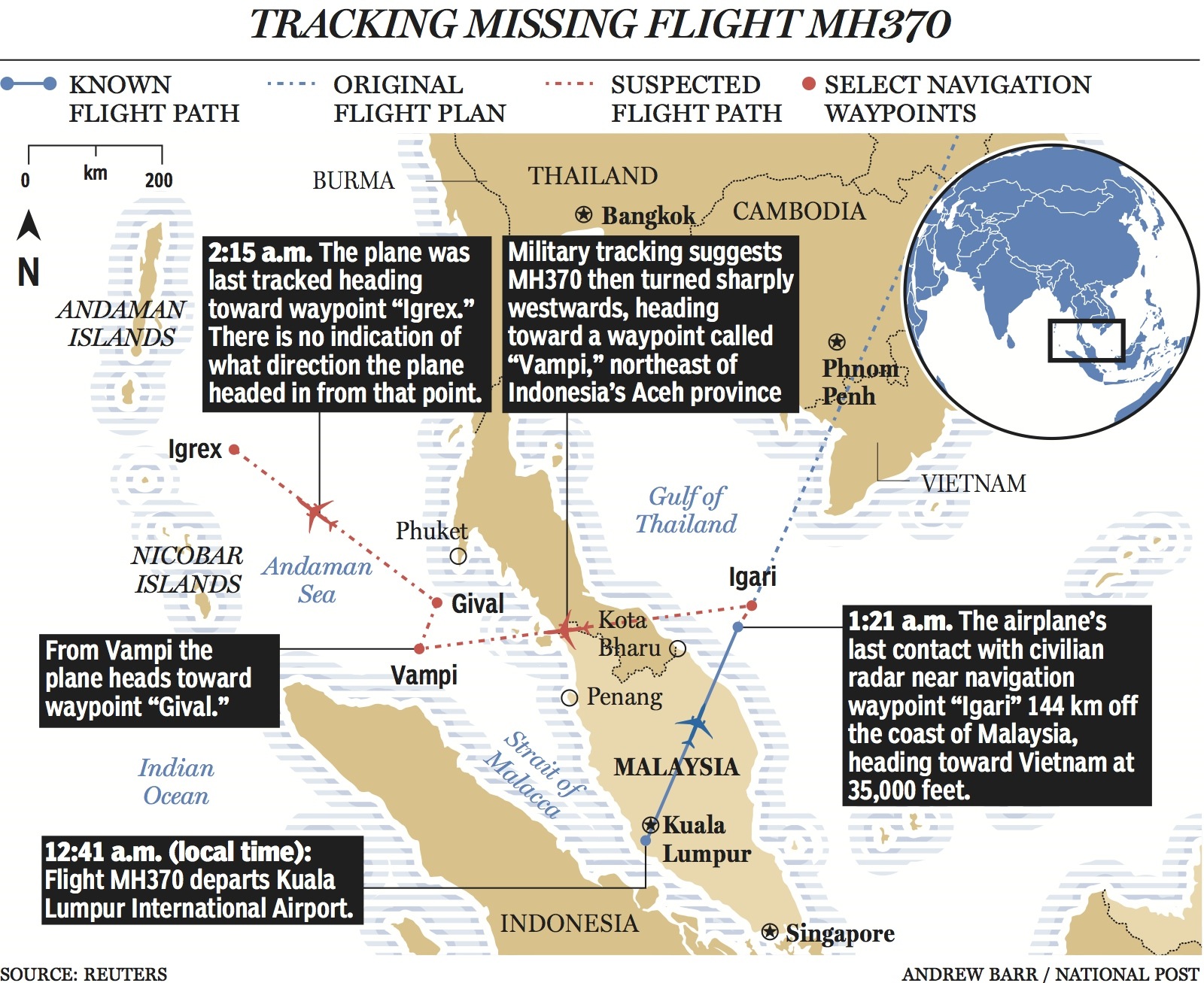
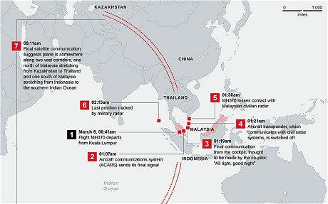
The analysis follows fresh examination of 7 satellite "pings" sent by MH370 between 1.11am and 8.11am Malaysian time on Saturday 8 March, when it vanished from radar screens
Britain's Inmarsat used a wave phenomenon discovered in the 19th century to analyze the seven pings its satellite picked up from Malaysia Airlines Flight MH370 to determine its final destination.
yahoo.comThe pings, automatically transmitted every hour from the aircraft after the rest of its communications systems had stopped, indicated it continued flying for hours after it disappeared from its flight path from Kuala Lumpur to Beijing.
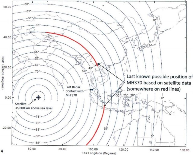
abc.net.auA map showing the location of the Inmarsat that received Satcom pings from MH370, and the plane’s radius from the satellite (calculated from the “ping” round-trip time).
Image via extremetech.comAbout 3 hours after MH370 went missing, Inmarsat began tracking the Boeing 777 through an onboard data system called Aero Classic
Every hour, Inmarsat's satellites would try to communicate with the aircraft, pinging it with a computerized question asking, in effect, "Are you there?" For several hours, Flight MH370 responded "Yes, I am," notifying engineers on the ground with a so-called handshake that the plane was still powered up.
"Our engineers looked at the time between the handshakes, and they realized that the object wasn't stationary under a satellite but moving away from it," Christopher McLaughlin, senior vice president of Inmarsat, said Thursday. "Over time, the engineers here recognized that there were a number of data points and that it had flown for several hours. We didn't know if it was on the northern or southern corridor."
washingtonpost.comUsing data from “pings” sent by MH370 to an Inmarsat satellite after the plane lost contact on 9 March, the company had established within four days that it had traveled along one of two vast arcs heading north across southern and central Asia or south across a vast expanse of ocean.
According to Inmarsat, the MH370 was reportedly flying at a cruising height above 30,000 feet
As far as Inmarsat can tell, the plane was flying at cruising height, above 30,000ft. They found no evidence of fluctuating heights being reported.
Image via bbcimg.co.uk"We looked at the Doppler effect, which is the change in frequency due to the movement of a satellite in its orbit. What that then gave us was a predicted path for the northerly route and a predicted path the southerly route," explained Chris McLaughlin, senior vice president of external affairs at Inmarsat. "That’s never been done before; our engineers came up with it as a unique contribution."
telegraph.co.ukInmarsat relayed its information to Malaysian officials by 12 March, but Malaysia's government did not publicly acknowledge it until 15 March
Malaysia began to redirect the search effort that day, to focus on the areas the information described. However, some officials involved with the probe warned that the lost days and wasted resources could impede the investigation.
telegraph.co.ukMeanwhile, Inmarsat's engineers carried out further analysis of the pings and came up with a much more detailed Doppler effect model for the northern and southern paths. By comparing these models with the trajectory of other aircraft on similar routes, they were able to establish an "extraordinary matching" between Inmarsat's predicted path to the south and the readings from other planes on that route. "By yesterday they were able to definitively say that the plane had undoubtedly taken the southern route," said McLaughlin.
The mathematics-based process used by Inmarsat and the AAIB to reveal the definitive path was described by Inmarsat Senior Vice President McLaughlin as "groundbreaking", who said, "we've done something new"
Here's how the process works in a nutshell: Inmarsat officials and engineers were able to determine whether the plane was flying away or toward the satellite's location by expansion or compression of the satellite's signal.
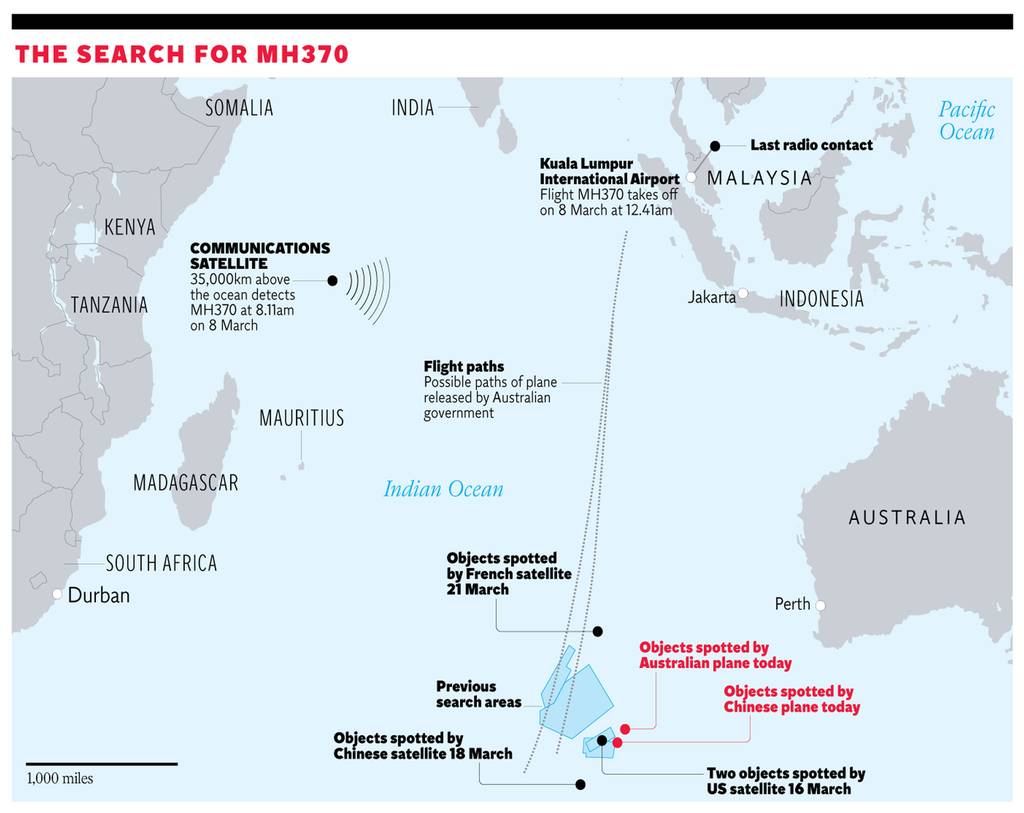
cnn.comGraphic shows the latest search efforts of planes scouring the southern Indian Ocean for debris today
Image via independent.co.ukWhat does expansion or compression mean? You may have heard about something called the Doppler effect. "If you sit at a train station and you listen to the train whistle -- the pitch of the whistle changes as it moves past. That's exactly what we have," explained CNN Meteorologist Chad Myers, who has studied Doppler technology.
"It's the Doppler effect that they're using on this ping or handshake back from the airplane. They know by nanoseconds whether that signal was compressed a little -- or expanded -- by whether the plane was moving closer or away from 64.5 degrees -- which is the latitude of the orbiting satellite." Each ping was analyzed for its direction of travel, Myers said.
cnn.comWATCH: Inmarsat Senior Vice President McLaughlin explain the satellite company's calculations:
The company said it was able to provide a location with a margin of error of about 100 miles but could not be more precise because the satellite which had been receiving MH370’s pings was a 1990s model and was not fitted with the GPS capability that would narrow the location to a handful of metres.


